Something extraordinary happened last Saturday at the frigid high point of the Greenland ice sheet, two miles in the sky and more than 500 miles above the Arctic Circle: It rained for the first time.
The rain at a research station — not just a few drops or a drizzle but a stream for several hours, as temperatures rose slightly above freezing — is yet another troubling sign of a changing Arctic, which is warming faster than any other region on the planet.
“It’s incredible, because it does write a new chapter in the book of Greenland,” said Marco Tedesco, a researcher at Lamont-Doherty Earth Observatory of Columbia University. “This is really new.”
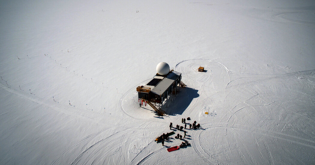
At the station, which is called Summit and is occupied year-round under the auspices of the National Science Foundation, there is no record of rain since observations began in the 1980s. And computer simulations show no evidence going back even further, said Thomas Mote, a climate scientist at the University of Georgia.
Above-freezing conditions at Summit are nearly as rare. Before this century, ice cores showed they had occurred only six times in the past 2,000 years, Martin Stendel, a senior researcher at the Danish Meteorological Institute, wrote in an email message.
But above-freezing temperatures have now occurred at Summit in 2012, 2019 and this year — three times in fewer than 10 years.
The Greenland ice sheet, which is up to two miles thick and covers about 650,000 square miles, has been losing more ice and contributing more to sea-level rise in recent decades as the Earth has warmed from human-caused emissions of carbon dioxide and other heat-trapping gases.
The surface of the ice sheet gains mass every year, because accumulation of snowfall is greater than surface melting. But overall, the sheet loses more ice through melting where it meets the ocean, and through the breaking-off of icebergs. On average over the past two decades, Greenland has lost more than 300 billion tons of ice each year.
This year will likely be an average one for surface accumulation, said Dr. Stendel, who is also coordinator of Polar Portal, a website that disseminates the results of Danish Arctic research. Heavy snowfall early in the year suggested it might be an above-average year for accumulation, but two periods of warming in July and another in early August changed that by causing widespread surface melting.
The warming that accompanied the rain last Saturday also caused melting over more than 50 percent of the ice sheet surface.
Dr. Mote said that these melting episodes were each “one-off” events. “But these events seem to be happening more and more frequently,” he said. “And that tells the story that we are seeing real evidence of climate change in Greenland.”
Last Saturday marked the first time since satellite monitoring began in 1979 that melting has occurred over more than half of the surface in mid-August, Dr. Mote said. Normally peak melting occurs in mid-July, as it did in 2012, when there was a huge melting event.
“By the time you get to the middle of August, you’re usually seeing a rapid retreat of melt activity and a decline of temperature,” he said.
Dr. Tedesco said the rain at Summit would not contribute directly to sea-level rise, because the water drains into the ice rather than to the ocean. “But if this is happening at Summit, the effect at lower elevations will be more violent,” he said. “And that ice is actually going to the ocean.”
Dr. Tedesco described the rain at Summit as “worrisome,” because it shows that even a little warming can have an effect in the region.
“Half a degree of warming can really change the state of the Arctic because you can go from frozen to liquid,” he said. “This is exactly what we’re seeing.”
The rain and melting last Saturday occurred when the jet stream, rather than flowing in its normal pattern from west to east, dipped southward over northeastern Canada. That brought low-pressure air over warmer waters, where it picked up heat and moisture.
The jet stream then looped back northward, bringing that air to southwestern Greenland from where it swept over the ice sheet. The warm air and even the moisture-laden clouds themselves caused temperatures to rise at Summit and the precipitation to fall as rain rather than snow, Dr. Mote said.
Some scientists have linked jet stream disruptions such as this, often referred to as “waviness,” to climate change in the Arctic, although that is still a subject of debate. But they are occurring, and are also creating so-called blocking patterns that can stall high-pressure air over a region.
That’s what occurred in the earlier melting episodes this summer. High-pressure air that stalled over the ice sheet led to clear skies that allowed more sunlight to reach the surface, melting more snow.


Average Rating